Services
Account Services
Subscribe to receive notifications if you want to stay updated about events in this site.
The Eionet password expires two years after it was last changed.
WISE Spatial Data reporting resourcesWater Framework Directive - River Basin Management Plans - 2022 reporting |
|
All enquiries can be directed to wfd.helpdesk@eionet.europa.eu
Please, check the Helpdesk FAQ. We also recommend to send the envelope link or the access database where your problem was detected.
WISE register
The WISE register contains the list of accepted EIONET and EU identifiers for spatial objects such as river basin districts, water bodies, etc..
The WISE register provides a unique and persistent URI for each of the spatial objects.
- River basin districts and sub-units: use the SpatialUnit vocabulary
- Surface and groundwater bodies: use the WaterBody vocabulary
- Monitoring sites: use the MonitoringSite vocabulary
- Bathing waters, sensitive areas, drinking water protected area and designated waters: use the WFDProtectedArea vocabulary
Guidance documents
Current version: 7.0.6.- WISE GIS Guidance v7.0.6 - Complete reporting guidance. Last update 2022-10-05.
- Protected Areas clarification note - Clarification on how to report protected areas.
- WISE Data Model v7.0.6 - Quick Reference Card - Condensed description.
- WISE Reportnet2 Guidance - How to access prefilled files and convert shapefiles to GML.
- QAQC Scripts - Documentation for the QAQC and scripts that are executed.
- Webinar 2022-09-19 - Slides of the Webinar on WISE-5 Spatial Data reporting - 2022-09-19
- Webinar 2021-06-08 - Slides of the Webinar on WFD Spatial Data reporting - 2021-06-08
- Webinar 2021-06-15 - Slides of the Webinar on WISE-5 Spatial Data reporting - 2021-06-15
- Webinar 2021-06-17 - Slides of the Webinar on BWD Spatial Data reporting - 2021-06-17
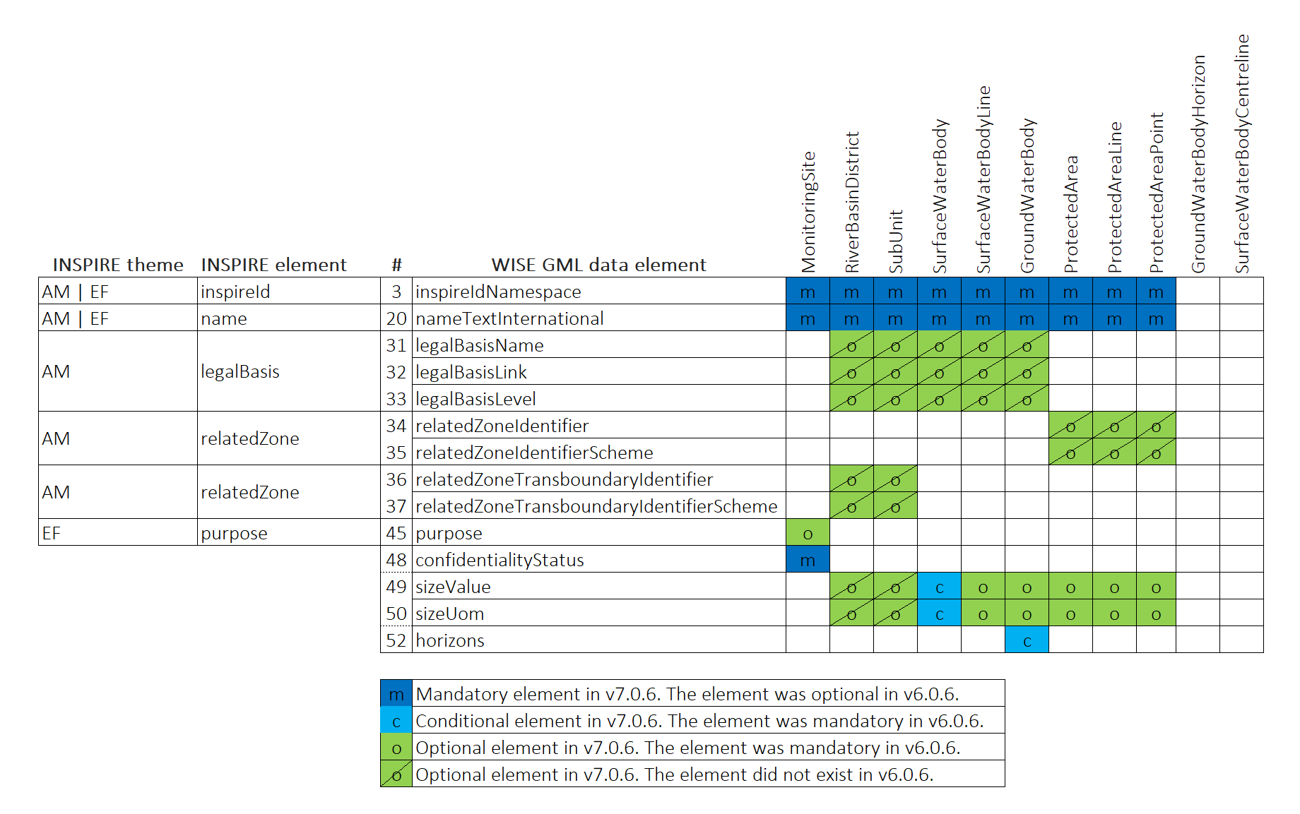
Spatial model quick reference
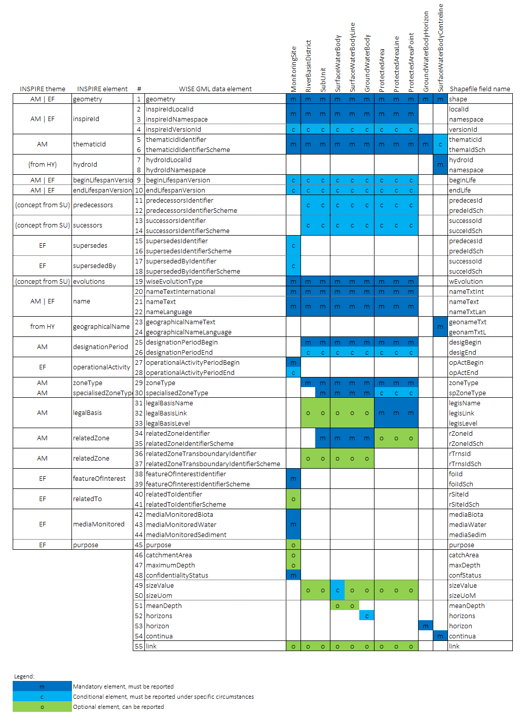
Spatial model changes between version 6.0.6 (used in 2016) and version 7.0.6
Quality Control specification
The following specifications are the basis of the quality control tools
UML Data specification
See below the UML diagrams for each dataset:
- RiverBasinDistrict_2022.png
- SubUnit_2022.png
- SurfaceWaterBody_2022.png
- SurfaceWaterBodyLine_2022.png
- SurfaceWaterBodyCentreline_2022.png
- GroundWaterBody_2022.png
- GroundWaterBodyHorizon_2022.png
- MonitoringSite_2022.png
- ProtectedArea_2022.png
- ProtectedAreaLine_2022.png
- ProtectedAreaPoint_2022.png
GML schemas
These are the GML schemas to allow the reporting of the spatial data:
- GML_Common_2022.xsd
- WFDCommon_2022.xsd
- GML_RiverBasinDistrict_2022.xsd
- GML_SubUnit_2022.xsd
- GML_SurfaceWaterBody_2022.xsd
- GML_SurfaceWaterBodyLine_2022.xsd
- GML_SurfaceWaterBodyCentreline_2022.xsd
- GML_GroundWaterBody_2022.xsd
- GML_GroundWaterBodyHorizon_2022.xsd
- GML_MonitoringSite_2022.xsd
- GML_ProtectedArea_2022.xsd
- GML_ProtectedAreaPoint_2022.xsd
- GML_ProtectedAreaLine_2022.xsd
Shapefile templates to prepare the spatial data
Shapefiles can be used to prepare the spatial data. The shapefiles must be converted to GML format (a conversion tool is available in the CDR envelopes). GML is the only format accepted in the final reporting of the spatial data.
These are the shapefile templates for each dataset:
- RiverBasinDistrict.zip
- SubUnit.zip
- SurfaceWaterBody.zip
- SurfaceWaterBodyLine.zip
- SurfaceWaterBodyCentreline.zip
- GroundWaterBody.zip
- GroundWaterBodyHorizon.zip
- MonitoringSite.zip
- ProtectedArea.zip
- ProtectedAreaLine.zip
- ProtectedAreaPoint.zip
- WFD2022_Shapefiles.zip Model shapefiles in a zip file for download
The projection files refer to the following coordinate reference systems:
- EPSG3035: ETRS89 / ETRS-LAEA, see more info
- EPSG4258: ETRS89, see more info
- EPSG4326: WGS84, see more info